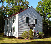
Namozine, Virginia
Unincorporated community in Virginia, United StatesNamozine is a rural unincorporated community near the eastern extremity of Amelia County, just south of the Appomattox River in the U.S. state of Virginia. It is the easternmost hamlet in the county and is situated around the intersections of SR 708 with SR 623 and SR 622. Roughly 2 miles to the southeast, Namozine Creek forms the county line, flowing northeast into the Appomattox at Lake Chesdin.
Read article


Top Questions
AI generatedMore questions
Nearby Places
Battle of Namozine Church
Battle of the American Civil War
Deep Creek (Appomattox River tributary)
River in the United States
Namozine Creek
Tributary of the Appomattox River in Virginia, United States
Ammon, Virginia
Unincorporated community in Virginia, United States

Mannboro, Virginia
Unincorporated community in Virginia, United States

Eppington
Historic house in Virginia, United States